I often fret and worry about an upcoming flight and 9 times out of 10 there turns out to be nothing to worry about. This time I had long ago scheduled a meeting in the Phoenix area and as the date approached the weather called for 10-20% chance of precipitation both in Placerville and Phoenix. Not bad enough to cancel, but with 100% chance on the day before this meant dealing with the tail end of a winter storm. I did fret a bit, and it turned out to be the 1 in 10 times the trip deserved the attention.
I watched the snow fall the evening before the flight, and got up well before dawn in order to have plenty of time to clear the snow off the car, preflight, fuel up and to launch not long after sun up.
Getting Into the Air
My first challenge that I was worried about was getting out of Placerville. Clouds often backup against the mountains and don’t clear up right away, which in the past has led to artful takeoffs in Class G airspace flying down under the clouds to the Sacramento Valley, where you can then turn on course. Luckily on this morning the clouds where about 1,500 feet off the deck so I was relieved that launching wouldn’t be a problem. I relaxed a bit – anticipating a nice flight from here on out.
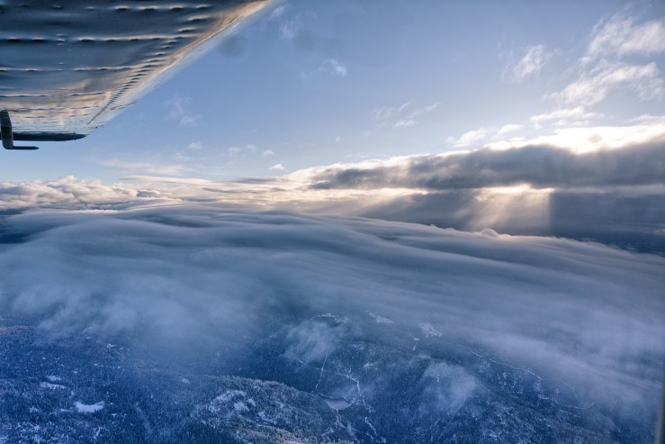
The Sierra Nevada Mountains
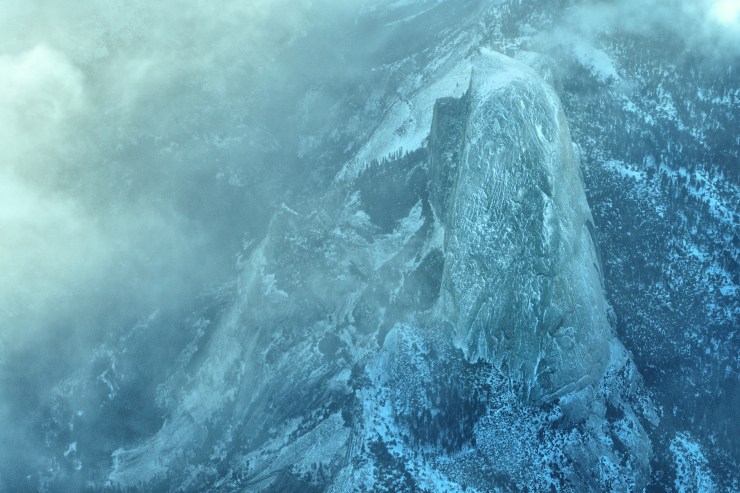
The next challenge was getting over the Sierras. It was still snowing in the high country around Lake Tahoe, and my plan was to fly south along the range and sneak under the clouds when able (not desirable because of high winds), or fly over when able, or fly all the way down to Palm Desert and head over there. There was more cloudiness than I anticipated. Flying under wasn’t an option. Or at least a smart one. I climbed and climbed while heading south and finally got enough altitude at around 17,000 feet (now on oxygen) to get over. I really wasn’t paying attention to where I was, but when I looked down I saw a clearing in the clouds with Half Dome below me. I should have circled for better photos but I was focused on clearing the mountains and the clouds so I took a quick photo and continued on.
I leveled off at 17,500, which is a convenient altitude since going above means wearing an oxygen mask instead of a nasal cannula, and also requires being on an instrument flight plan. I prefer not to fly on a flight plan when lots of clouds are around as you often are required to fly where ATC wants you to fly, which may mean icing.

The Wind and the Cold
Wind is weather too! Words to live by. I did check the winds the night before and was worried as it showed the jet stream low and fast, right over my flight path. It meant I should fly high to stay above mountain turbulence, but it also meant a possible windy and challenging landing. I had to tell myself to prepare to divert should a stiff crosswind landing be required.

I did set a ground-speed record of 240 knots, which meant a tail wind of around 75 knots. It was extremely cold too at -25 degrees F, also an inflight record for me. I wore ski gloves for that section of the flight, although they came off often to work the knobs and iPad. My feet were frozen. The heater just can’t keep up and since I run lean-of-peak the engine runs cooler, but the heater therefore does too.
The good news was that at that temperature it is too cold for icing conditions, but I was above any clouds anyway.
Scud Running?
As I neared west of Las Vegas, and now at 15,500 feet, I approached a cloud bank with the tops somewhat higher than I was. I decided to go under it. I dove and got under at about 11,000 feet, but what I saw wasn’t encouraging. Mt. Charleston was in the clouds which was to be expected, but many other peaks were too, and there were wispy clouds all the way to the ground. Scud run in this stuff for another hour? No way, so I did a 180, then several climbing 360s as I eventually leveled back off at 17,500 again, clear of the clouds.
I was now surprised to find out that instead of the forecast scattered cloud conditions, my destination airport was only marginal VFR (with mountains around). Now what to do? I had some time to plan so I studied the charts before calling Las Angeles Center on the radio and asking for an instrument flight plan into Deer Valley / Phoenix, where the on-ground temperature was 60 degrees. There wasn’t any rain showing up anywhere so the clouds seemed ubiquitous but broken up with apparently little moisture. Starting in the clear, I thought an approach to Deer Valley would work out without much icing.
Icing
A few moments after ATC told me to descend, I dropped into the tops of the clouds below me and instantly the windscreen went opaque with ice. OK, so much for the benign clouds without much moisture theory. My plane doesn’t have wing or propeller deicing – only the standard pitot tube heater which keeps some of the instruments like the airspeed indicator from failing. I read that the tops of clouds tend to hold more moisture than the lower clouds. In my limited experience, they don’t tend to – they absolutely do. In this case I was in and out of clouds but in looking out at my left wing thankfully I never got more than thin white coating. My defroster made a small hole and I waited to descend into warmer air. The ground temperature was 60 degrees so for heaven’s sake it had to clear up at some point, but that turned out to be around 9-10,000 feet (which makes sense given a standard lapse rate).
Severe Turbulence
As I entered the clouds I noted build ups looming above me straight ahead about 50 miles out. I was turned to the right almost immediately, so I wasn’t too concerned. No rain showed on my Avidyne 540. However around 9,000 feet when I was starting to relax with the temperature above freezing, all hell broke loose. My camera bag sitting on the passenger seat shot up and some lenses came out and fell on the floor. The plane banked severely, and I was terrified. Of course I’ve hit severe turbulence a number of times in my flying career, but never in IMC (clouds). I stared (fixated you could say) at the attitude indicator because my wings were banking wildly from side to side and I had to continually recover. In hindsight it wasn’t too difficult but at the time I was waiting for perhaps something to tilt the wings beyond 90 degrees, in which case it would have definitely become more difficult to recover. As pilots we have read accident reports where witnesses “observed the aircraft falling out of the bottom of the clouds”. Damn, no one wants to be that pilot.
Luckily, it only lasted about 15 minutes. Oh wait, I meant 15 seconds, but it felt like 15 minutes. Then it settled down into merely heavy to moderate turbulence. I did note there was now yellow/green rain on the display but nowhere near me. I still don’t know if that was convective turbulence or mechanical turbulence from heavy winds over terrain. Either way, it sure scared the crap out of me.
Cross-wind Landing
I broke out at 4,500 feet, about 2,000 feet above the ground. So I didn’t have to do a full instrument approach which was fine by me. I’d been into Deer Valley before and had been surprised with the volume of traffic, though I now know of the airport’s claim that it is the busiest general aviation airport in the country (a title which I thought went to Merrill Field in Alaska). The traffic comes from the many flight training schools based there for the “350 flying days a year”
This day was apparently one of the 15 non-flying days a year. Except for me and one other airplane the radio was quiet and I was cleared to land while still about 5 miles out. The wind was 220 degrees, 22 knots with gusts up to 30 knots. I was landing on runway 25 (250 degrees) so the wind was pretty well lined up with the runway, thank goodness. I still had a healthy crab on final and I kept some extra speed for possible wind shear. I did a decent wing-down, one-wheel landing and slowly taxied in while the wind buffeted the plane.
It was definitely nice to be on the ground!
As I write this I have to go back to Phoenix the day after tomorrow. The weather calls for another winter storm with 70% chance of precipitation. I just made reservations on American Airlines.


Crossing The Sierra at Yosemite is always a challenge. At winds above 30 kts, Its a no go usually. I would have thought you could ‘back-track’ a little and cross at Reno then LAS-Phx.
Since moving to Williams, Az (south of Grand Canyon) and getting a 310, the speeds are such that its just as timely to take the western route (PMD-BKF-FAT) as the eastern (LAS SWR, FMG).
Today, FF gives something in between these routes with a crossing near Mono lake at 14.5. Still on O2 but just a canula.
Stay safe Ney. Its nice to know there are still guys like you out there. –best to the family.
Bud Robison
Thank you Bud for the note. Yes, I should have crossed near Reno were the tops didn’t look all that high. I didn’t anticipate the clouds rising so much going south while I flew south and climbed. I fly out of Placerville so I need some time to climb and it is always more compelling to fly somewhere than to just do 360s and climb.
Agreed. I learned my lesson trying to depart Mammoth Lakes in the afternoon…. 🙂