During a period of unsettled weather I flew to Bend Oregon with my business partner Graeme for a meeting. The flight up was a little bumpy but fortunately we landed in a mild crosswind before the wind really picked up about an hour later. As soon as we landed I started to focus on weather for the return trip the next day. Whoops, maybe I should have looked sooner. The weather looked pretty ugly with thunderstorms forecast all up and down the west coast.
We had the meeting, lunch and drove straight to the Bend airport. Graeme needed to make another flight from Sacramento so I flew him to Redmond Oregon where he could take a commercial flight. I told him my flight might not make it though I was putting my odds at 75% or more – I was pretty sure I could dodge or wait-out thunderstorms on my way home and eventually get there. Really, how often are there lines of thunderstorms in the Sacramento Valley? Almost never. However I didn’t want to the extra pressure of having to deliver Graeme per a set schedule, so having him take a commercial flight was a good decision.
Turns out it was a very good decision.

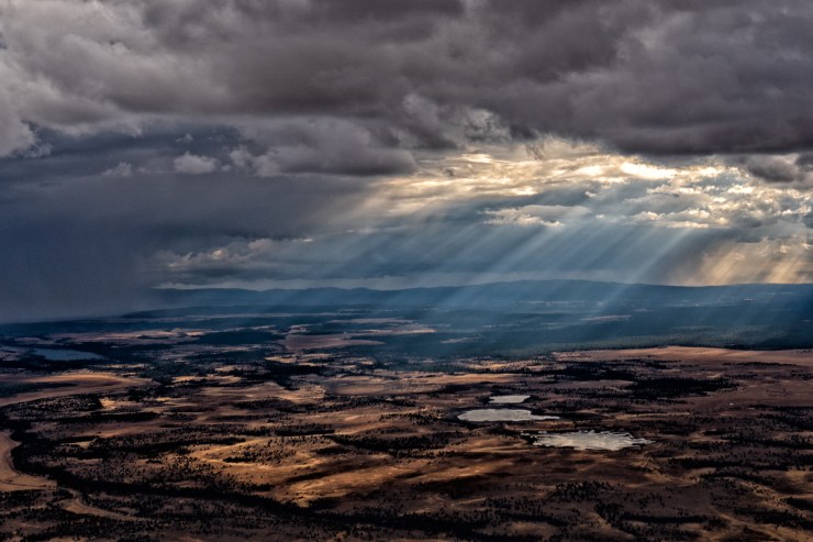
The main crux of the flight would be getting over / through the mountains into the upper Sacramento Valley. I was easily dodging thunderstorms but the radar picture of further south looked bad and was getting worse. And my options were getting more limited as I flew south – I could fly way out to Nevada to try to get around the line of thunderstorms or maybe fly all the way to the coast and try to go down and around.
I elected to land at Fall River Mills and shortly thereafter decided to just stay the night. They have a little airport office with a couch and fortunately I had a sleeping bag with me. I walked into town for Mexican food in a light rain, then about noon the next day I was able to take off after the rain stopped, though it was still a challenging flight with lots of rain and thunderstorms in the area.

I stayed VFR but had to climb to 12,000 feet to get over some buildups, then swooped down and under a big hole in the clouds where the ceilings where 3-4,000 feet and you could then easily avoid the downpours. I landed quite exhausted – from both a rocky night’s sleep on a couch and the constant focus on the weather.

Hi Ney,
Could you please post your bread crumb trail for that flight?
Curious what would not be attractive about flying ACV-STS-SAC then home, after the stuff moves further east. And if it didn’t move fast enough, there are freeways and Amtrak under you. Planes move fast, even Cessnas, but I remind people that the shortest route is often not the safest. Don’t worry about rubber banding the route. Besides, you could have stopped by the decent restaurant at STS!
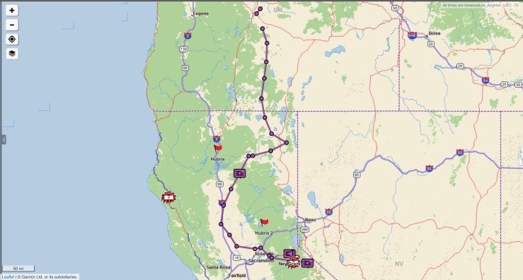
It doesn’t appear you can add images to comments, so I’ll insert the track in the post. That track is for both flights home, stopping in the middle at Fall River Mills. You can see I was heading east but then went direct Fall River Mills and landed. By then everything had gotten worse, worse than the radar photo. So getting out of the mountains west would really mean northwest and losing ground.
I pretended for awhile that I might fly home later but a beer at the Mexican restaurant was too tempting!