How to Fly a Small Plane Over a Big Mountain
If you have time and an airplane, the best way to fly over or around Denali / Mt. McKinley is to have patience and monitor the weather. 90% of the visitors to Denali don’t actually see the mountain!
We were planning on heading south on the Kenai peninsula when the weather report at Denali was for clear weather in a few days. So we dropped everything and headed north. Betsy and our friends were in two vans so they drove.

I headed out in my Cessna 182 ahead of time, alone. I was thankful to be alone because the wind and turbulence were ferocious. I was happy that the wind was mostly straight down the runway. Being a day early also gave me time to visit the on-field flight service station in Talkeetna and also walk into Talkeetna Air and talk to one of the tour pilots.
The FSS guy said yes, it looks like one of the best days of the season, if not the best. In fact the guy was trying to convince his parents to drive up from Kenai. The tour pilot from Talkeetna Air was super nice and we talked for some time. Essentially I just wanted to be sure I didn’t get in their way on the mountain, but he went further and gave me route suggestions.
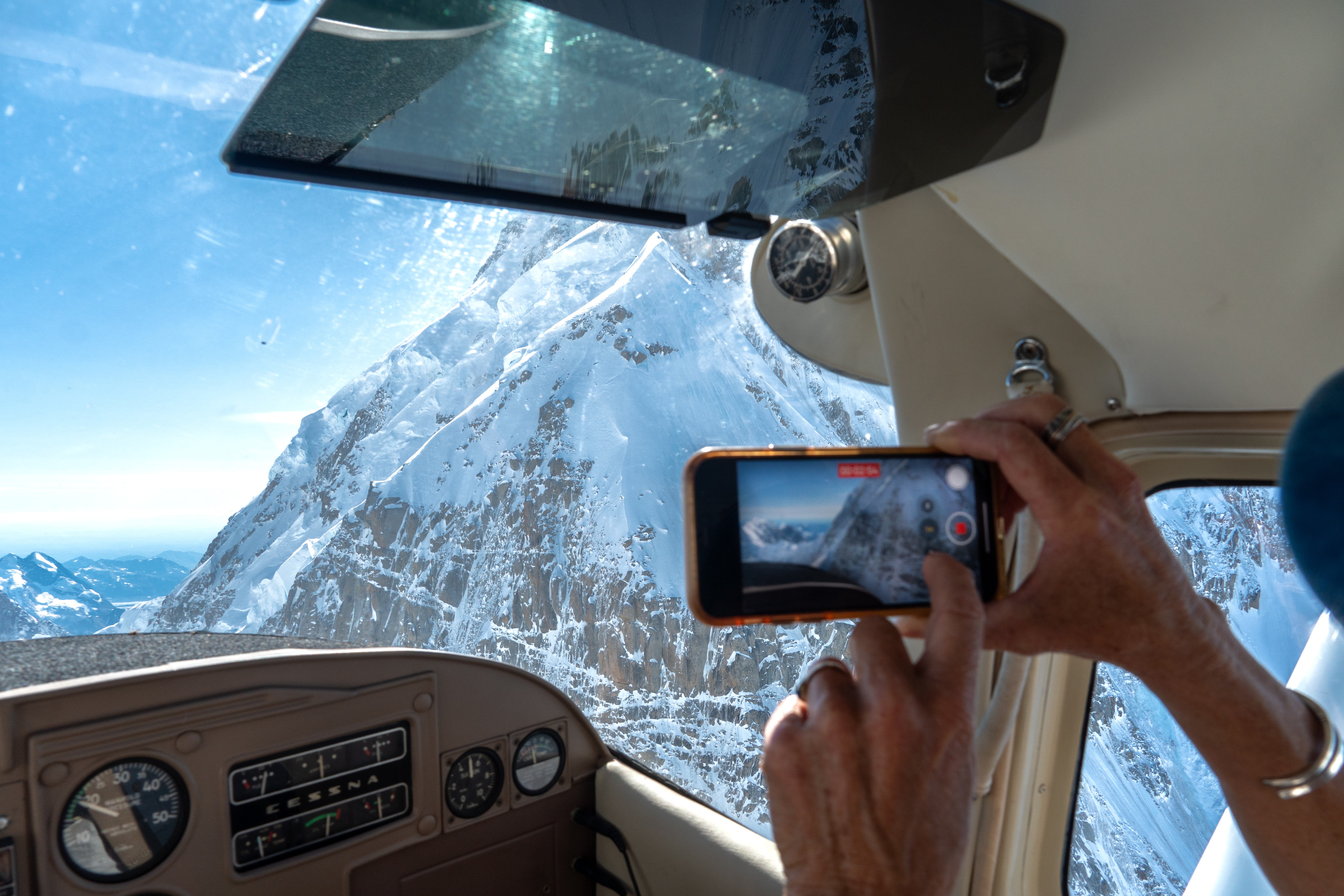
Our route went up the Kahiltna Glacier to the head of the glacier just before a large amphitheater, then right through Ruth Gap (see video). I was a little anxious because the gap was not evident at all until you got relatively close to it. I was flying low enough (I forget exactly, but I think 11-12,000 feet) that I wasn’t going to make it out of that amphitheater except by executing a 180 turn. I was preparing to do that when the gap came into view and we went for it. It was exciting for sure! We then ended up in the famous Ruth Gorge. We went over to check out The Mooses Tooth, then flew down the Ruth.

For those interested in doing a tour themselves, here are some tips:
- Find out when the tour planes head out, as they all go at about the same time. Then depart 30 minutes later and you may have the mountain to yourself.
- The tour guys with their turbine engines don’t waste fuel on doing any kind of pattern, so they’ll self-announce their position relative to the nearest waypoints (Highway Camp and The Gravel Pit) and are careful to space themselves out.
- An ADS-B in display is super helpful on the mountain. They all have it and use it.
- In fact they don’t use the radio as much as I expected, instead relying on ADS-B to monitor where everyone is.
- Be aware that if a plane is in the shadow of mountains (in relation to other planes), its transponder will not broadcast its position.
- Fly to the right side when heading up and down glaciers.
- The day before our flight I pulled up traffic on my iPad using Foreflight and got a sense of where and how high the tour planes were flying on my route. Then I flew 1,000 feet higher as I figured they would be more comfortable flying low than I would.
- Download the reporting points file (KMZ/KML file) from the National Park Service website. Foreflight will upload this file and then you can use the overlay feature to display the reporting points. Very handy!

Wow. That looks like a perfect day to cruise around Denali. Was the air smooth? Did Betsy do it with you? Kudos to her if so!
Stunning